Wandelkaart - Topografische kaart OL15 OS Explorer Map Purbeck and South Dorset | Ordnance Survey (9780319242544)
Poole, Dorchester, Weymouth & Swanage

- ISBN / CODE: 9780319242544
- Editie: meest recente versie
- Schaal: 1:25000
- Uitgever: Ordnance Survey
- Soort: Topografische kaart, Wandelkaart
- Serie: OS Explorer Map
- Taal: Engels
- Bindwijze: -
- Uitvoering: Papier
- Schrijf als eerste een review
-
€ 19,50
Op voorraad. Voor 17.00 uur op werkdagen besteld, morgen in huis in Nederland Levertijd Belgie
Gratis verzending in Nederland vanaf €35,-

-
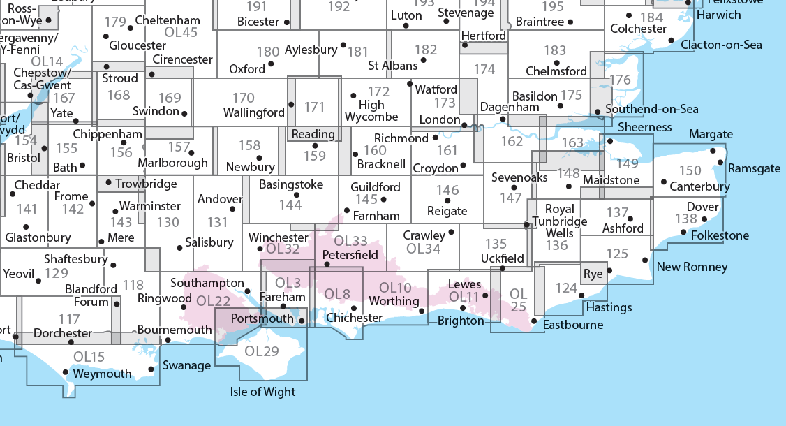
Overzichtskaart Explorer 25.000 topografische kaarten zuid Engeland


Producten op deze overzichtskaart:
Klik op een product om naar de pagina van dat product te gaan.
- Wandelkaart - Topografische kaart 117 OS Explorer Map Cerne Abbas & Bere Regis | Ordnance Survey
- Wandelkaart - Topografische kaart 118 OS Explorer Map Shaftesbury & Cranborne Chase | Ordnance Survey
- Wandelkaart - Topografische kaart 129 OS Explorer Map Yeovil & Sherborne | Ordnance Survey
- Wandelkaart - Topografische kaart 130 OS Explorer Map Salisbury & Stonehenge | Ordnance Survey
- Wandelkaart - Topografische kaart 131 OS Explorer Map Romsey, Andover & Test Valley | Ordnance Survey
- Wandelkaart - Topografische kaart 135 OS Explorer Map Ashdown Forest (greenw) | Ordnance Survey
- Wandelkaart - Topografische kaart 141 OS Explorer Map Cheddar Gorge, Mendip Hills West | Ordnance Survey
- Wandelkaart - Topografische kaart 142 OS Explorer Map Shepton Mallet , Mendip Hills East | Ordnance Survey
- Wandelkaart - Topografische kaart 143 OS Explorer Map Warminster, Trowbridge | Ordnance Survey
- Wandelkaart - Topografische kaart 144 OS Explorer Map Basingstoke, Alto, Whitchurch | Ordnance Survey
- Wandelkaart - Topografische kaart 145 OS Explorer Map Guildford, Farnham | Ordnance Survey
- Wandelkaart - Topografische kaart 146 OS Explorer Map Dorking, Box Hill, Reigate | Ordnance Survey
- Wandelkaart - Topografische kaart 147 OS Explorer Map Sevenoaks and Tonbridge | Ordnance Survey
- Wandelkaart - Topografische kaart 154 OS Explorer Map Bristol West, Portishead | Ordnance Survey
- Wandelkaart - Topografische kaart 155 OS Explorer Map Bristol, Bath | Ordnance Survey
- Wandelkaart - Topografische kaart 156 OS Explorer Map Chippenham, Bradford-on-Avon | Ordnance Survey
- Wandelkaart - Topografische kaart 157 OS Explorer Map Marlborough, Savernake Forest | Ordnance Survey
- Wandelkaart - Topografische kaart 158 OS Explorer Map Newbury, Hungerford | Ordnance Survey
- Wandelkaart - Topografische kaart 159 OS Explorer Map Reading, Wokingham & Pangbourne Map | Thames Path | Ordnance Survey
- Wandelkaart - Topografische kaart 160 OS Explorer Map Windsor, Weybridge, Bracknell | Thames Path | Ordnance Survey
- Wandelkaart - Topografische kaart 161 OS Explorer Map London South (greenw.m) | Ordnance Survey
- Wandelkaart - Topografische kaart 162 OS Explorer Map Greenwich, Gravesend | Ordnance Survey
- Wandelkaart - Topografische kaart 167 OS Explorer Map Thornbury, Dursley, Yate | Ordnance Survey
- Wandelkaart - Topografische kaart 168 OS Explorer Map Stroud, Tetbury, Malmesbury | Ordnance Survey
- Wandelkaart - Topografische kaart 169 OS Explorer Map Cirencester, Swindon | Ordnance Survey
- Wandelkaart - Topografische kaart 170 OS Explorer Map Abingdon, Wantage & Vale of White Horse | Ordnance Survey
- Wandelkaart - Topografische kaart 171 OS Explorer Map Chiltern Hills West | Ordnance Survey
- Wandelkaart - Topografische kaart 172 OS Explorer Map Chiltern Hills East | Ordnance Survey
- Wandelkaart - Topografische kaart 173 OS Explorer Map London North | Ordnance Survey
- Wandelkaart - Topografische kaart 174 OS Explorer Map Epping Forest, Lee Valley | Ordnance Survey
- Wandelkaart - Topografische kaart 179 OS Explorer Map Gloucester, Cheltenham, Stroud | Ordnance Survey
- Wandelkaart - Topografische kaart 180 OS Explorer Map Oxford | Ordnance Survey
- Wandelkaart - Topografische kaart 182 OS Explorer Map St-Albans, Hatfield | Ordnance Survey
- Wandelkaart - Topografische kaart OL03 OS Explorer Map Meon Valley - Portsmouth, Gosport & Fareham | Ordnance Survey
- Wandelkaart - Topografische kaart OL08 OS Explorer Map Chichester, South Harting & Selsey | Ordnance Survey
- Wandelkaart - Topografische kaart OL10 OS Explorer Map Arundel - Pulborough - Worthing | Ordnance Survey
- Wandelkaart - Topografische kaart OL11 OS Explorer Map Brighton & Hove, Lewes & Burgess Hill | Ordnance Survey
- Wandelkaart - Topografische kaart OL14 OS Explorer Map Wye Valley - Forest of Dean - Dyfryn Gwy | Ordnance Survey
- Wandelkaart - Topografische kaart OL15 OS Explorer Map Purbeck and South Dorset | Ordnance Survey
- Wandelkaart - Topografische kaart OL25 OS Explorer Map Eastbourne & Beachy Head | Ordnance Survey
- Wandelkaart - Topografische kaart OL29 OS Explorer Map Isle of Wight | Ordnance Survey
- Wandelkaart - Topografische kaart OL32 OS Explorer Map Winchester - New Alresford - East Meon | Ordnance Survey
- Wandelkaart - Topografische kaart OL33 OS Explorer Map Haslemere - Petersfield - Midhurst - Selborne | Ordnance Survey
- Wandelkaart - Topografische kaart OL34 OS Explorer Map Crawley - Horsham - Cranleigh - Billinghurst | Ordnance Survey
-
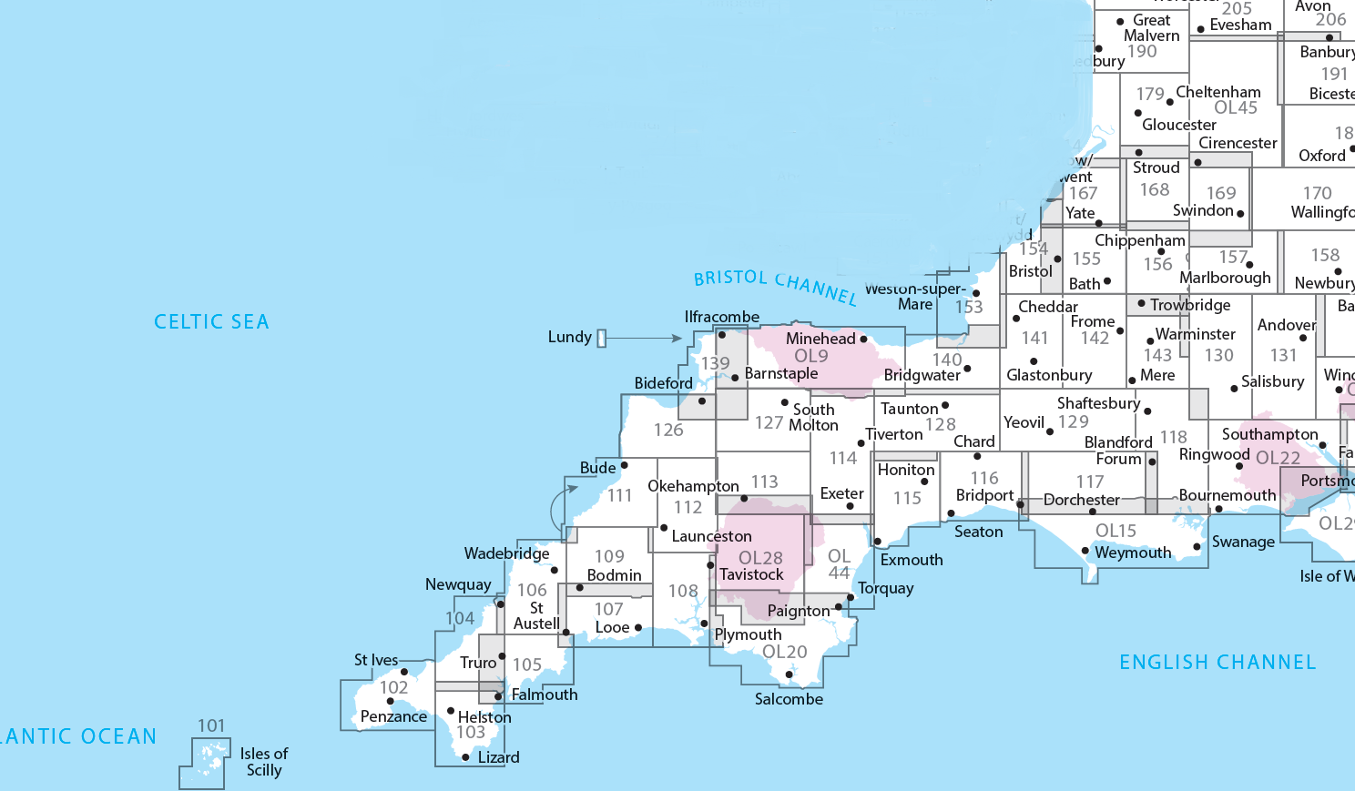
Overzichtskaart Explorer 25.000 topografische kaarten zuidwest Engeland - Devon - Cornwall


Producten op deze overzichtskaart:
Klik op een product om naar de pagina van dat product te gaan.
- Wandelkaart - Topografische kaart 101 OS Explorer Map Isles of Scilly | Ordnance Survey
- Wandelkaart - Topografische kaart 102 OS Explorer Map Land's End | Ordnance Survey
- Wandelkaart - Topografische kaart 103 OS Explorer Map The Lizard | Ordnance Survey
- Wandelkaart - Topografische kaart 104 OS Explorer Map Redruth & St Agnes | Ordnance Survey
- Wandelkaart - Topografische kaart 105 OS Explorer Map Falmouth & Mevagissey | Ordnance Survey
- Wandelkaart - Topografische kaart 106 OS Explorer Map Newquay & Padstow | Ordnance Survey
- Wandelkaart - Topografische kaart 107 OS Explorer Map St Austell & Liskeard | Ordnance Survey
- Wandelkaart - Topografische kaart 108 OS Explorer Map Lower Tamar Valley & Plymouth | Ordnance Survey
- Wandelkaart - Topografische kaart 109 OS Explorer Map Bodmin Moor | Ordnance Survey
- Wandelkaart - Topografische kaart 111 OS Explorer Map Bude, Boscastle & Tintagel | Ordnance Survey
- Wandelkaart - Topografische kaart 112 OS Explorer Map Launceston & Holsworthy | Ordnance Survey
- Wandelkaart - Topografische kaart 113 OS Explorer Map Okehampton | Ordnance Survey
- Wandelkaart - Topografische kaart 114 OS Explorer Map Exeter - Exe Valley | Ordnance Survey
- Wandelkaart - Topografische kaart 115 OS Explorer Map Exmouth & Sidmouth | Ordnance Survey
- Wandelkaart - Topografische kaart 116 OS Explorer Map Lyme Regis & Bridport | Ordnance Survey
- Wandelkaart - Topografische kaart 117 OS Explorer Map Cerne Abbas & Bere Regis | Ordnance Survey
- Wandelkaart - Topografische kaart 118 OS Explorer Map Shaftesbury & Cranborne Chase | Ordnance Survey
- Wandelkaart - Topografische kaart 126 OS Explorer Map Clovelly & Hartland | Ordnance Survey
- Wandelkaart - Topografische kaart 127 OS Explorer Map South Molton & Chulmleigh | Ordnance Survey
- Wandelkaart - Topografische kaart 128 OS Explorer Map Taunton & Blackdown Hills | Ordnance Survey
- Wandelkaart - Topografische kaart 129 OS Explorer Map Yeovil & Sherborne | Ordnance Survey
- Wandelkaart - Topografische kaart 130 OS Explorer Map Salisbury & Stonehenge | Ordnance Survey
- Wandelkaart - Topografische kaart 131 OS Explorer Map Romsey, Andover & Test Valley | Ordnance Survey
- Wandelkaart - Topografische kaart 139 OS Explorer Map Bideford & Ilfracombe & Barnstaple | Ordnance Survey
- Wandelkaart - Topografische kaart 140 OS Explorer Map Quantock Hills, Bridgewater | Ordnance Survey
- Wandelkaart - Topografische kaart 141 OS Explorer Map Cheddar Gorge, Mendip Hills West | Ordnance Survey
- Wandelkaart - Topografische kaart 142 OS Explorer Map Shepton Mallet , Mendip Hills East | Ordnance Survey
- Wandelkaart - Topografische kaart 143 OS Explorer Map Warminster, Trowbridge | Ordnance Survey
- Wandelkaart - Topografische kaart 153 OS Explorer Map Weston-super-Mare, Bleadon Hill | Ordnance Survey
- Wandelkaart - Topografische kaart 154 OS Explorer Map Bristol West, Portishead | Ordnance Survey
- Wandelkaart - Topografische kaart 155 OS Explorer Map Bristol, Bath | Ordnance Survey
- Wandelkaart - Topografische kaart 156 OS Explorer Map Chippenham, Bradford-on-Avon | Ordnance Survey
- Wandelkaart - Topografische kaart 157 OS Explorer Map Marlborough, Savernake Forest | Ordnance Survey
- Wandelkaart - Topografische kaart 158 OS Explorer Map Newbury, Hungerford | Ordnance Survey
- Wandelkaart - Topografische kaart 167 OS Explorer Map Thornbury, Dursley, Yate | Ordnance Survey
- Wandelkaart - Topografische kaart 168 OS Explorer Map Stroud, Tetbury, Malmesbury | Ordnance Survey
- Wandelkaart - Topografische kaart 169 OS Explorer Map Cirencester, Swindon | Ordnance Survey
- Wandelkaart - Topografische kaart 170 OS Explorer Map Abingdon, Wantage & Vale of White Horse | Ordnance Survey
- Wandelkaart - Topografische kaart 179 OS Explorer Map Gloucester, Cheltenham, Stroud | Ordnance Survey
- Wandelkaart - Topografische kaart OL09 OS Explorer Map Exmoor | Ordnance Survey
- Wandelkaart - Topografische kaart OL15 OS Explorer Map Purbeck and South Dorset | Ordnance Survey
- Wandelkaart - Topografische kaart OL20 OS Explorer Map South Devon | Ordnance Survey
- Wandelkaart - Topografische kaart OL22 OS Explorer Map New Forest | Ordnance Survey
- Wandelkaart - Topografische kaart OL28 OS Explorer Map Dartmoor | Ordnance Survey
- Wandelkaart - Topografische kaart OL44 OS Explorer Map Torquay & Dawlish | Ordnance Survey
- Wandelkaart - Topografische kaart OL45 OS Explorer Map The Cotswolds | Ordnance Survey
-
Overzichtskaart Explorer 25.000 wandelkaarten zuid Engeland
Producten op deze overzichtskaart:
Klik op een product om naar de pagina van dat product te gaan.
- Wandelkaart - Topografische kaart 117 OS Explorer Map Cerne Abbas & Bere Regis | Ordnance Survey
- Wandelkaart - Topografische kaart 118 OS Explorer Map Shaftesbury & Cranborne Chase | Ordnance Survey
- Wandelkaart - Topografische kaart 129 OS Explorer Map Yeovil & Sherborne | Ordnance Survey
- Wandelkaart - Topografische kaart 130 OS Explorer Map Salisbury & Stonehenge | Ordnance Survey
- Wandelkaart - Topografische kaart 131 OS Explorer Map Romsey, Andover & Test Valley | Ordnance Survey
- Wandelkaart - Topografische kaart 135 OS Explorer Map Ashdown Forest (greenw) | Ordnance Survey
- Wandelkaart - Topografische kaart 141 OS Explorer Map Cheddar Gorge, Mendip Hills West | Ordnance Survey
- Wandelkaart - Topografische kaart 142 OS Explorer Map Shepton Mallet , Mendip Hills East | Ordnance Survey
- Wandelkaart - Topografische kaart 143 OS Explorer Map Warminster, Trowbridge | Ordnance Survey
- Wandelkaart - Topografische kaart 144 OS Explorer Map Basingstoke, Alto, Whitchurch | Ordnance Survey
- Wandelkaart - Topografische kaart 145 OS Explorer Map Guildford, Farnham | Ordnance Survey
- Wandelkaart - Topografische kaart 146 OS Explorer Map Dorking, Box Hill, Reigate | Ordnance Survey
- Wandelkaart - Topografische kaart 147 OS Explorer Map Sevenoaks and Tonbridge | Ordnance Survey
- Wandelkaart - Topografische kaart 154 OS Explorer Map Bristol West, Portishead | Ordnance Survey
- Wandelkaart - Topografische kaart 155 OS Explorer Map Bristol, Bath | Ordnance Survey
- Wandelkaart - Topografische kaart 156 OS Explorer Map Chippenham, Bradford-on-Avon | Ordnance Survey
- Wandelkaart - Topografische kaart 157 OS Explorer Map Marlborough, Savernake Forest | Ordnance Survey
- Wandelkaart - Topografische kaart 158 OS Explorer Map Newbury, Hungerford | Ordnance Survey
- Wandelkaart - Topografische kaart 159 OS Explorer Map Reading, Wokingham & Pangbourne Map | Thames Path | Ordnance Survey
- Wandelkaart - Topografische kaart 160 OS Explorer Map Windsor, Weybridge, Bracknell | Thames Path | Ordnance Survey
- Wandelkaart - Topografische kaart 161 OS Explorer Map London South (greenw.m) | Ordnance Survey
- Wandelkaart - Topografische kaart 162 OS Explorer Map Greenwich, Gravesend | Ordnance Survey
- Wandelkaart - Topografische kaart 167 OS Explorer Map Thornbury, Dursley, Yate | Ordnance Survey
- Wandelkaart - Topografische kaart 168 OS Explorer Map Stroud, Tetbury, Malmesbury | Ordnance Survey
- Wandelkaart - Topografische kaart 169 OS Explorer Map Cirencester, Swindon | Ordnance Survey
- Wandelkaart - Topografische kaart 170 OS Explorer Map Abingdon, Wantage & Vale of White Horse | Ordnance Survey
- Wandelkaart - Topografische kaart 171 OS Explorer Map Chiltern Hills West | Ordnance Survey
- Wandelkaart - Topografische kaart 172 OS Explorer Map Chiltern Hills East | Ordnance Survey
- Wandelkaart - Topografische kaart 173 OS Explorer Map London North | Ordnance Survey
- Wandelkaart - Topografische kaart 174 OS Explorer Map Epping Forest, Lee Valley | Ordnance Survey
- Wandelkaart - Topografische kaart 179 OS Explorer Map Gloucester, Cheltenham, Stroud | Ordnance Survey
- Wandelkaart - Topografische kaart 180 OS Explorer Map Oxford | Ordnance Survey
- Wandelkaart - Topografische kaart 182 OS Explorer Map St-Albans, Hatfield | Ordnance Survey
- Wandelkaart - Topografische kaart OL03 OS Explorer Map Meon Valley - Portsmouth, Gosport & Fareham | Ordnance Survey
- Wandelkaart - Topografische kaart OL08 OS Explorer Map Chichester, South Harting & Selsey | Ordnance Survey
- Wandelkaart - Topografische kaart OL10 OS Explorer Map Arundel - Pulborough - Worthing | Ordnance Survey
- Wandelkaart - Topografische kaart OL11 OS Explorer Map Brighton & Hove, Lewes & Burgess Hill | Ordnance Survey
- Wandelkaart - Topografische kaart OL14 OS Explorer Map Wye Valley - Forest of Dean - Dyfryn Gwy | Ordnance Survey
- Wandelkaart - Topografische kaart OL15 OS Explorer Map Purbeck and South Dorset | Ordnance Survey
- Wandelkaart - Topografische kaart OL25 OS Explorer Map Eastbourne & Beachy Head | Ordnance Survey
- Wandelkaart - Topografische kaart OL29 OS Explorer Map Isle of Wight | Ordnance Survey
- Wandelkaart - Topografische kaart OL32 OS Explorer Map Winchester - New Alresford - East Meon | Ordnance Survey
- Wandelkaart - Topografische kaart OL33 OS Explorer Map Haslemere - Petersfield - Midhurst - Selborne | Ordnance Survey
- Wandelkaart - Topografische kaart OL34 OS Explorer Map Crawley - Horsham - Cranleigh - Billinghurst | Ordnance Survey
-
Overzichtskaart Explorer 25.000 wandelkaarten zuidwest Engeland - Devon - Cornwall

Producten op deze overzichtskaart:
Klik op een product om naar de pagina van dat product te gaan.
- Wandelkaart - Topografische kaart 101 OS Explorer Map Isles of Scilly | Ordnance Survey
- Wandelkaart - Topografische kaart 102 OS Explorer Map Land's End | Ordnance Survey
- Wandelkaart - Topografische kaart 103 OS Explorer Map The Lizard | Ordnance Survey
- Wandelkaart - Topografische kaart 104 OS Explorer Map Redruth & St Agnes | Ordnance Survey
- Wandelkaart - Topografische kaart 105 OS Explorer Map Falmouth & Mevagissey | Ordnance Survey
- Wandelkaart - Topografische kaart 106 OS Explorer Map Newquay & Padstow | Ordnance Survey
- Wandelkaart - Topografische kaart 107 OS Explorer Map St Austell & Liskeard | Ordnance Survey
- Wandelkaart - Topografische kaart 108 OS Explorer Map Lower Tamar Valley & Plymouth | Ordnance Survey
- Wandelkaart - Topografische kaart 109 OS Explorer Map Bodmin Moor | Ordnance Survey
- Wandelkaart - Topografische kaart 111 OS Explorer Map Bude, Boscastle & Tintagel | Ordnance Survey
- Wandelkaart - Topografische kaart 112 OS Explorer Map Launceston & Holsworthy | Ordnance Survey
- Wandelkaart - Topografische kaart 113 OS Explorer Map Okehampton | Ordnance Survey
- Wandelkaart - Topografische kaart 114 OS Explorer Map Exeter - Exe Valley | Ordnance Survey
- Wandelkaart - Topografische kaart 115 OS Explorer Map Exmouth & Sidmouth | Ordnance Survey
- Wandelkaart - Topografische kaart 116 OS Explorer Map Lyme Regis & Bridport | Ordnance Survey
- Wandelkaart - Topografische kaart 117 OS Explorer Map Cerne Abbas & Bere Regis | Ordnance Survey
- Wandelkaart - Topografische kaart 118 OS Explorer Map Shaftesbury & Cranborne Chase | Ordnance Survey
- Wandelkaart - Topografische kaart 126 OS Explorer Map Clovelly & Hartland | Ordnance Survey
- Wandelkaart - Topografische kaart 127 OS Explorer Map South Molton & Chulmleigh | Ordnance Survey
- Wandelkaart - Topografische kaart 128 OS Explorer Map Taunton & Blackdown Hills | Ordnance Survey
- Wandelkaart - Topografische kaart 129 OS Explorer Map Yeovil & Sherborne | Ordnance Survey
- Wandelkaart - Topografische kaart 130 OS Explorer Map Salisbury & Stonehenge | Ordnance Survey
- Wandelkaart - Topografische kaart 131 OS Explorer Map Romsey, Andover & Test Valley | Ordnance Survey
- Wandelkaart - Topografische kaart 139 OS Explorer Map Bideford & Ilfracombe & Barnstaple | Ordnance Survey
- Wandelkaart - Topografische kaart 140 OS Explorer Map Quantock Hills, Bridgewater | Ordnance Survey
- Wandelkaart - Topografische kaart 141 OS Explorer Map Cheddar Gorge, Mendip Hills West | Ordnance Survey
- Wandelkaart - Topografische kaart 142 OS Explorer Map Shepton Mallet , Mendip Hills East | Ordnance Survey
- Wandelkaart - Topografische kaart 143 OS Explorer Map Warminster, Trowbridge | Ordnance Survey
- Wandelkaart - Topografische kaart 153 OS Explorer Map Weston-super-Mare, Bleadon Hill | Ordnance Survey
- Wandelkaart - Topografische kaart 154 OS Explorer Map Bristol West, Portishead | Ordnance Survey
- Wandelkaart - Topografische kaart 155 OS Explorer Map Bristol, Bath | Ordnance Survey
- Wandelkaart - Topografische kaart 156 OS Explorer Map Chippenham, Bradford-on-Avon | Ordnance Survey
- Wandelkaart - Topografische kaart 157 OS Explorer Map Marlborough, Savernake Forest | Ordnance Survey
- Wandelkaart - Topografische kaart 158 OS Explorer Map Newbury, Hungerford | Ordnance Survey
- Wandelkaart - Topografische kaart 167 OS Explorer Map Thornbury, Dursley, Yate | Ordnance Survey
- Wandelkaart - Topografische kaart 168 OS Explorer Map Stroud, Tetbury, Malmesbury | Ordnance Survey
- Wandelkaart - Topografische kaart 169 OS Explorer Map Cirencester, Swindon | Ordnance Survey
- Wandelkaart - Topografische kaart 170 OS Explorer Map Abingdon, Wantage & Vale of White Horse | Ordnance Survey
- Wandelkaart - Topografische kaart 179 OS Explorer Map Gloucester, Cheltenham, Stroud | Ordnance Survey
- Wandelkaart - Topografische kaart OL09 OS Explorer Map Exmoor | Ordnance Survey
- Wandelkaart - Topografische kaart OL15 OS Explorer Map Purbeck and South Dorset | Ordnance Survey
- Wandelkaart - Topografische kaart OL20 OS Explorer Map South Devon | Ordnance Survey
- Wandelkaart - Topografische kaart OL22 OS Explorer Map New Forest | Ordnance Survey
- Wandelkaart - Topografische kaart OL28 OS Explorer Map Dartmoor | Ordnance Survey
- Wandelkaart - Topografische kaart OL44 OS Explorer Map Torquay & Dawlish | Ordnance Survey
- Wandelkaart - Topografische kaart OL45 OS Explorer Map The Cotswolds | Ordnance Survey
Overzichtskaarten
Beschrijving
- - Hunt for fossils and dinosaur tracks on the unique Jurassic Coast beaches of Kimmeridge Bay, Lulworth Cove and the iconic sweeping shingle ridge of Chesil Beach
- - Discover the world-famous Sandbanks Beach in Poole, climb Europe’s largest Iron Age hillfort at Maiden Castle and relax in sunny Weymouth, home of the sailing at London 2012
- - Explore the Purbeck Peninsula with its chalk cliffs, the magnificent ruin of Corfe Castle, Victorian pier at Swanage and Brownsea Island
Een van de beste detailkaarten die er op de wereld gemaakt worden: zeer gedetailleerd, prachtig helder kleurgebruik, veel topografische aspecten en - zeer belangrijk - allerlei toeristische en recreatieve aspecten zijn ingetekend. De perfecte kaart voor vakantie en vrije tijd: wandelen, fietsen of gewoon de omgeving verkennen. Door de grootte van de kaart, voor- en achterzijde,
bestrijkt het een behoorlijk groot gebied!
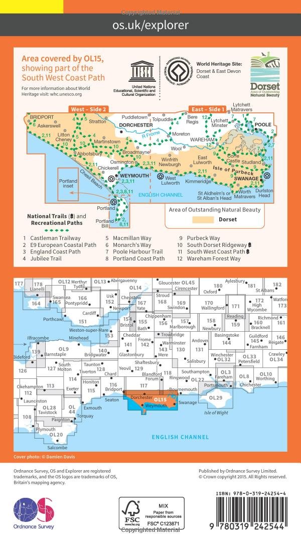
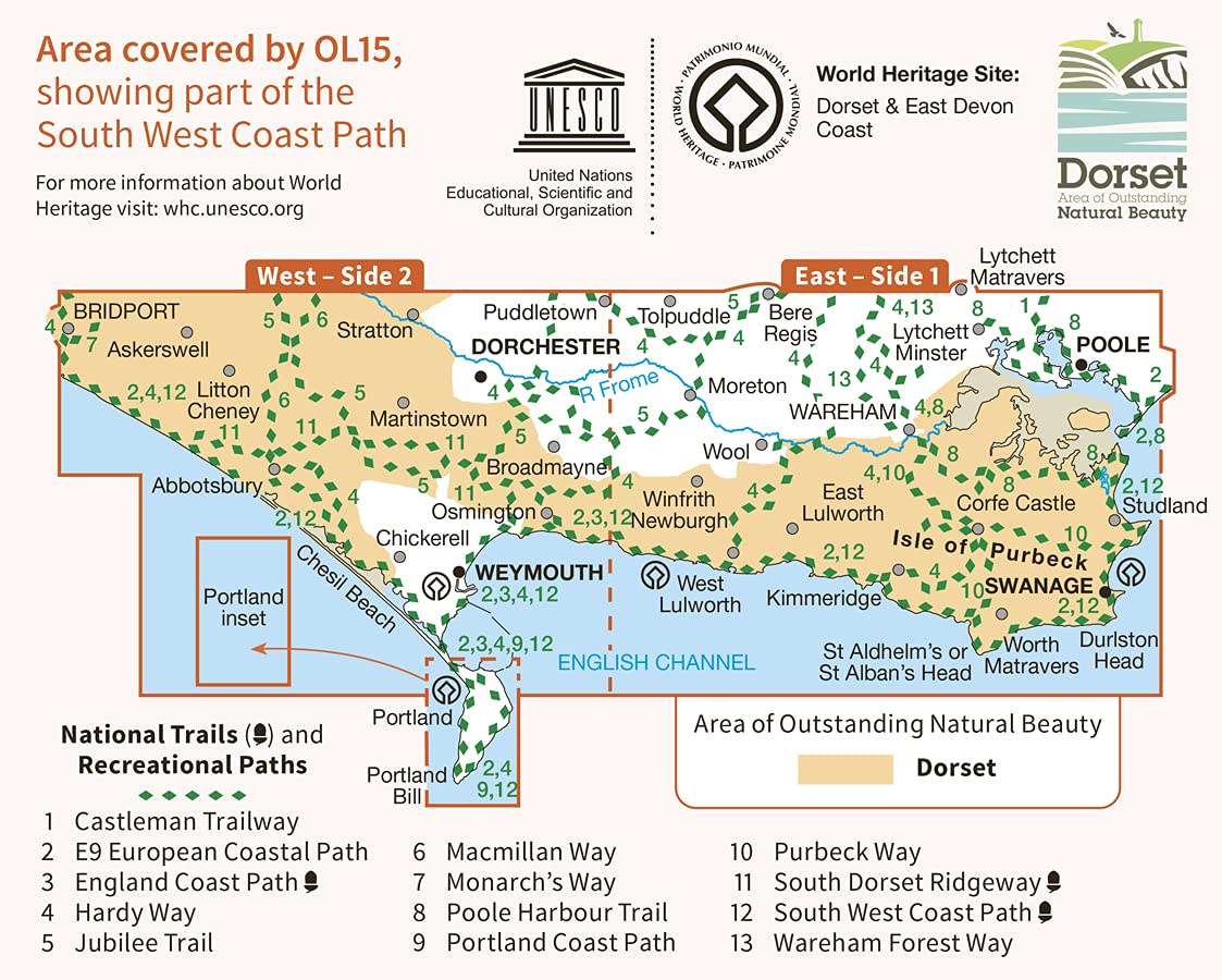
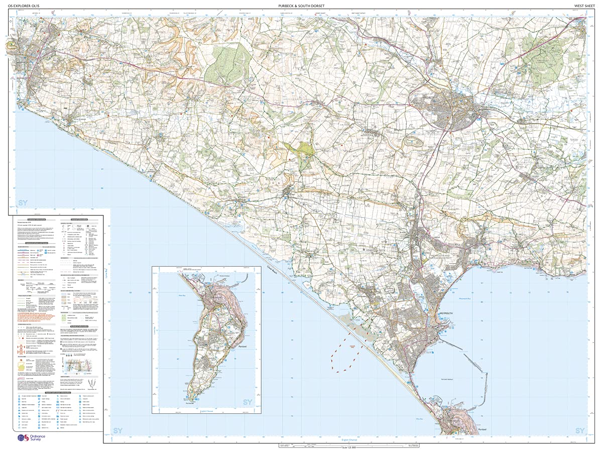
Purbeck and South Dorset, Poole, Dorchester, Weymouth & Swanage. Showing part of the South West Coast Path
These highly detailed maps show all the administrative boundaries, settlements as small as isolated farms, road network down to unfenced roads and country tracks, and field boundaries (hedges and drystone walls) which make navigation across the countryside much easier. Steep gradients on roads are indicated. Various landmarks, eg. powerlines, archaeological sites, windmills, churches and lighthouses are shown, and additional graphics indicate natural terrain features such as cliffs, scree, mud and vegetation variations. Contour interval is 5 metres in the lower parts of the country and 10 metres in the uplands, and spot heights are marked. Each map covers an area of 30 x 20km (i.e. approx. 19 x 12 miles), with some double-sided maps covering more, as indicated in the individual descriptions. The maps are fully GPS compatible, with the National Grid shown at 1km intervals and latitude and longitude indicated by margin ticks at 1'.
Explorer maps show a large amount of information for ramblers and tourists. Public rights of way are shown (except in Scotland), together with other routes with public access: National Trails and Recreational Paths, permitted paths and bridleways, and selected cycle routes. Open access land created under the Countryside and Rights of Way Act 2000 is marked. Tourist information includes caravan and camp sites, Park & Ride locations, recreation/leisure/sport centres, museums, historic buildings, English Heritage and National Trust sites, rural pubs, etc. The map legend is in English only, except for the tourist information content which is also in French and German.
Reviews
Geen reviews gevonden voor dit product.
Schrijf een review
Graag horen wij wat u van dit artikel vindt. Vindt u het goed, leuk, mooi, slecht, lelijk, onbruikbaar of erg handig: schrijf gerust alles op! Het is niet alleen leuk om te doen maar u informeert andere klanten er ook nog mee!
Ook interessant voor europa/engeland/South-West-England
-

Wandelatlas South West Coast Path -
€ 17,50Wandelatlassen ♦ Devon - Cornwall -

Wandelgids South West Coast Path: So
€ 9,95Wandelgidsen ♦ Devon - Cornwall -

Reisverhaal Het Zoutpad | Raynor Win
€ 15,00Reisverhalen ♦ Devon - Cornwall -

Wandelkaart - Topografische kaart 10
€ 19,50Topografische kaarten ♦ Devon - Cornwall -

Reisgids The South West Coast Path |
€ 27,95Reisgidsen ♦ Devon - Cornwall