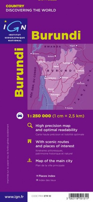
Wegenkaart - landkaart Burundi | IGN - Institut Géographique National (3282118501311)

- ISBN / CODE: 3282118501311
- Schaal: 1:250000
- Uitgever: IGN - Institut Géographique National
- Soort: Wegenkaart
- Serie: Découverte du Monde
- Taal: Frans
- Bindwijze: -
- Uitvoering: -
- Schrijf als eerste een review
-
€ 11,75
Uitverkocht, nooit meer leverbaar
Beschrijving
Goede overzichtskaart van het Franse Cartografisch Instituut. Met autoroutes en stadsplattegronden van de belangrijkste steden.
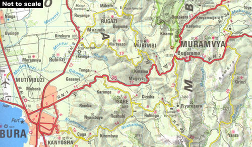
Detailed map of Burundi with small villages and settlements, and a street plan of Bujumbura. Contours at 200m and relief shading indicate the terrain and the map also shows various types of vegetation. Roads are shown with distances and petrol stations, and tracks are also marked. Other information includes national parks ans reserves, hotels and other accommodation, hospitals, various religious establishments, and places of interest. Latitude/longitude lines are drawn at 15' intervals.
The map is indexed and includes a street plan of Bujumbura, a distance table, and an administrative diagram. The legend is in French only.
Reviews
Geen reviews gevonden voor dit product.
Schrijf een review
Graag horen wij wat u van dit artikel vindt. Vindt u het goed, leuk, mooi, slecht, lelijk, onbruikbaar of erg handig: schrijf gerust alles op! Het is niet alleen leuk om te doen maar u informeert andere klanten er ook nog mee!
Ook interessant voor afrika/burundi
-

Vogelgids Birds of East Africa | Blo
€ 49,95Vogelgidsen Burundi -

Reisgids East Africa- Oost Afrika |
€ 27,95Reisgidsen Burundi -

Wegenkaart - landkaart Tanzania, Rwa
€ 11,95Wegenkaarten Burundi -

Natuurgids Stuarts' Field Guide to t
€ 27,95Natuurgidsen Angola -

Natuurgids Field Guide to the Larger
€ 25,95Natuurgidsen Botswana