Wegenkaart - landkaart Democratic Republic of the Congo - Demokratische Republiek Kongo - Zaire | Carthographia (9789633529751)
- ISBN / CODE: 9789633529751
- Schaal: 1:3300000
- Uitgever: Carthographia
- Soort: Wegenkaart
- Taal: Engels
- Schrijf als eerste een review
-
€ 9,25
Uitverkocht, nooit meer leverbaar

Beschrijving
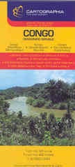
Uitstekende overzichtskaart van de Demokratische republiek Kongo (Zaire) met duidelijk kaartbeeld en stadsplattegrond van Kinshasa.
Detailed road map with an inset showing a street plan of the central part of Kinshasa. Relief shading shows the topography. Six different types of roads and tracks are shown, indicating those passable only in the dry season, with intermediate driving distances on main roads. The map also shows railways, airports and ports, river navigational limits and shipping routes on Lake Tanganika. National parks and game reserves, waterfalls and reservoirs, dams, caves, mangroves and volcanoes are also marked, as well as various religious establishments, monuments, viewpoints and tourist sites, beaches and campsites, etc.
An inset shows a street plan of the central part of Kinshasa, with a note that some street names are subject to change. Index of place names is printed on the reverse of the map. Longitude and latitude lines are drawn at 2° intervals. Map legend includes English.
Reviews
Geen reviews gevonden voor dit product.
Schrijf een review
Graag horen wij wat u van dit artikel vindt. Vindt u het goed, leuk, mooi, slecht, lelijk, onbruikbaar of erg handig: schrijf gerust alles op! Het is niet alleen leuk om te doen maar u informeert andere klanten er ook nog mee!
Ook interessant voor afrika/demokratischerepubliekkongo
-

Reisgids Democratic Republic of Cong
€ 24,50Reisgidsen Demokratische Republiek Kongo -

Reisverhaal Congo | David Grégoire V
€ 27,50Reisverhalen Demokratische Republiek Kongo -

Wandelkaart Rwenzori Mountains | EWP
€ 17,95Wandelkaarten Demokratische Republiek Kongo -

Wegenkaart - landkaart Kongo - Congo
€ 17,95Wegenkaarten Demokratische Republiek Kongo -

Natuurgids Stuarts' Field Guide to t
€ 27,95Natuurgidsen Angola