Webshop voor reisgidsen & landkaarten

Winkelmandje

Uw winkelmandje bevat 0 items t.w.v. € 0,00

Naar winkelwagen

FaceBook Twitter

Wandelgids Walking guide to UK County Tops - Groot-Brittannië | Cicerone (9781852846299)

  • ISBN / Code:
    9781852846299
  • Aantal blz.:
    206
  • Uitgever:
    Cicerone Press
  • Editie:
    2011
  • Soort:
    Wandelgids
  • Taal:
    Engels
  • Beoordeling:

€ 19,95

Afbeeldingen

Wandelgids Walking guide to UK County Tops - Groot-Brittannië | Cicerone

Inspiring guide to 82 walking routes reaching the tops of the UK's 91 historic counties in England, Scotland, Wales and Northern Ireland, from Inverness-shire's Ben Nevis (1344m) to Huntingdonshire's Boring Field (80m) visiting 10 national parks and the full range of UK countryside. OS maps, colour photography, many county facts.

Wherever you find yourself in the UK – among the Munros of Scotland, the fens of East Anglia, the rolling moors of the west-country or the suburban sprawl of of a big city, there‘s a county top on your doorstep waiting to be discovered.

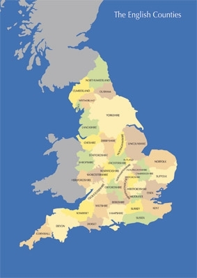
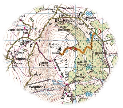
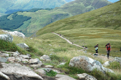
Ranging from 80m Boring Field in Huntingdonshire to 1344m Ben Nevis in Inverness-shire, the 91 tops of the historic counties of the UK are a sundry collection of hills and mountains spanning the length and breadth of England, Wales, Scotland and Northern Ireland. Some rank among the finest summits in the UK: Ben Lomond, Helvellyn, Pen y Fan, The Cheviot, Scafell Pike, Slieve Donard and Worcestershire Beacon. Others are less known, appearing in strange and wonderful places: A military firing zone in Yorkshire, the tundra plateau of the Cairngorms and a back garden in south-east London. Every county top has its own story, whether it is the mystery of the Grey Man of Macdui on Ben Macdui, the Mass Trespass of 1932 on Kinder Scout or the devastating wartime death toll on Shropshire’s Brown Clee Hill.

Author Jonny Muir was the first person to visit them all in one 5000-mile cycling and walking adventure, over a three-month period, and he shares his preferred routes, gradings and lots of incidental facts and figures for each one here.

Overview map

INTRODUCTION

The historic counties
Defining a county top
Using this guide
Getting there
Safety in the hills

ENGLAND

Introduction
1 Cornwall – Brown Willy 420m
2 Devon – High Willhays 621m
3 Somerset – Dunkery Beacon 519m
4 Dorset – Lewesdon Hill 279m
5 Sussex – Black Down 280m
6 Surrey – Leith Hill 294m
7 Kent – Betsom’s Hill 251m
8 Middlesex – Bushey Heath 153m
9 Bedfordshire – Dunstable Downs 243m
10 Buckinghamshire – Haddington Hill 267m / Hertfordshire – Pavis Wood 244m
11 Berkshire – Walbury Hill 297m / Hampshire – Pilot Hill 286m
12 Oxfordshire – Bald Hill 257m
13 Wiltshire – Milk Hill 295m
14 Gloucestershire – Cleeve Common 330m
15 Herefordshire – Black Mountain 703m
16 Worcestershire – Worcestershire Beacon 425m
17 Warwickshire – Ebrington Hill 261m
18 Northamptonshire – Arbury Hill 225m
19 Shropshire – Brown Clee Hill 540m
20 Staffordshire – Cheeks Hill 520m
21 Leicestershire – Bardon Hill 278m
22 Derbyshire – Kinder Scout 636m
23 Nottinghamshire – Silverhill 205m
24 Rutland – Cold Overton Park 197m
25 Huntingdonshire – Boring Field 80m
26 Cambridgeshire – Great Chishill 146m / Essex – Chrishall Common 147m
27 Suffolk – Great Wood 128m
28 Norfolk – Beacon Hill 105m
29 Lincolnshire – Normanby Top 168m
30 Cheshire – Black Hill 582m
31 Lancashire – The Old Man of Coniston 803m
32 Durham – Burnhope Seat 746m
33 Yorkshire – Mickle Fell 788m
34 Cumberland – Scafell Pike 978m
35 Westmorland – Helvellyn 950m
36 Northumberland – The Cheviot 815m

WALES

Introduction
37 Flintshire – Moel Famau 562m
38 Anglesey – Holyhead Mountain 220m
39 Caernarvonshire – Snowdon 1085m
40 Denbighshire – Cadair Berwyn 830m / Montgomeryshire – Moel Sych 827m
41 Merionethshire – Aran Fawddwy 907m
42 Cardiganshire – Plynlimon 752m
43 Pembrokeshire – Foel Cwmcerwyn 536m
44 Carmarthenshire – Fan Foel 781m
45 Glamorgan – Craig y Llyn 600m
46 Brecknockshire – Pen y Fan 886m
47 Monmouthshire – Chwarel y Fan 679m
48 Radnorshire – Great Rhos 660m

SCOTLAND

Introduction
49 Roxburghshire – Hangingstone Hill 743m
50 East Lothian – Meikle Says Law 535m / Berwickshire – Meikle Says Law south shoulder 532m
51 West Lothian – Cairnpapple Hill 312m
52 Midlothian – Blackhope Scar 651m
53 Lanarkshire – Culter Fell 748m
54 Peeblesshire and Selkirkshire – Broad Law 840m
55 Dumfriesshire – White Coomb 821m
56 Ayrshire – Kirriereoch Hill shoulder 781m / Kirkcudbrightshire – Merrick 843m
57 Wigtownshire – Craigairie Fell 321m
58 Buteshire – Goatfell 874m
59 Renfrewshire – Hill of Stake 522m
60 Stirlingshire – Ben Lomond 974m
61 Dunbartonshire – Ben Vorlich 943m
62 Perthshire – Ben Lawers 1214m
63 Clackmannanshire – Ben Cleuch 721m
64 Kinross – Innerdouny Hill 497m
65 Fife – West Lomond 522m
66 Kincardineshire – Mount Battock 778m
67 Angus – Glas Maol 1068m
68 Aberdeenshire and Banffshire – Ben Macdui 1309m
69 Morayshire – Carn a’ Ghille Chearr 710m
70 Nairnshire – Carn Glas-choire 659m
71 Argyll – Bidean Nam Bian 1150m
72 Inverness-shire – Ben Nevis 1344m
73 Ross and Cromarty – Carn Eige 1183m
74 Sutherland – Ben More Assynt 998m
75 Caithness – Morven 706m
76 Orkney – Ward Hill 479m
77 Shetland – Ronas Hill 450m

NORTHERN IRELAND

Introduction
78 County Down – Slieve Donard 853m
79 County Armagh – Slieve Gullion 576m
80 County Fermanagh – Cuilcagh 666m
81 County Londonderry and County Tyrone – Sawel Mountain 678m
82 County Antrim – Trostan 550m

Appendix 1 The UK’s historic county tops by height
Appendix 2 The present-day county tops of England, Wales and Scotland by height

Reviews:

Schrijf zelf een review

Geen reviews gevonden voor dit product.

Contactgegevens

Reisboekwinkel de Zwerver
Oude Kijk in ’t Jatstraat 43 - 45
9712 EC Groningen

T: 050 - 3 12 69 50
E: info@dezwerver.nl

Twitter:
twitter.com/dezwerver


Facebook:
facebook.com/reisboekwinkeldezwerver


Openingstijden
Maandag 13:00 - 18:00
Dinsdag 10:00 - 18:00
Woensdag 10:00 - 18:00
Donderdag 10:00 - 21:00
Vrijdag 10:00 - 18:00
Zaterdag 10:00 - 17:00

Bankgegevens
Bank: 29.68.41.838
IBAN: NL53FRBK0296841838
BIC: FRBKNL2L

Kamer van Koophandel
KvK: 02039426

BTW-Nummer

NL 1752.01.006B01


Win een reisgids!

Geef je nu op voor onze nieuwsbrief en maak kans op een Lonely Planet Reisgids naar keuze te winnen!

Onder elke 100 aanmeldingen verloten wij een Lonely Planet Reisgids naar keuze!

Je ontvangt de nieuwsbrief 1x per maand en blijft dan helemaal op de hoogte van nieuwe reisgidsen en landkaarten.

Bekijk hier onze laatste nieuwsbrief:
> Nieuwsbrief mei 2012


Wordt fan van ons!

Wordt fan van Reisboekwinkel de Zwerver en win een Scratch Map!
Like us!